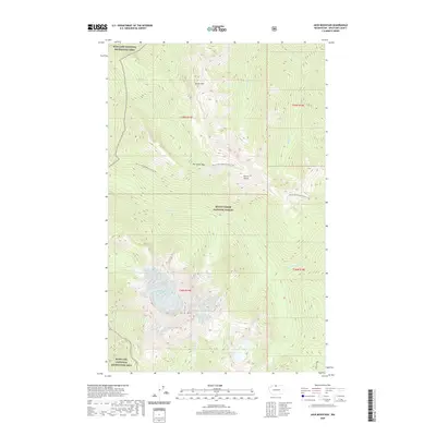
2020 Map of Jack Mountain
USGS Topo · Published 2020About this map
Jack Mtn dominates the southern landscape of this Cascades survey, where high-elevation terrain meets the protected wilderness of the Mount Baker National Forest. The map documents a complex drainage network feeding into the Skagit River watershed, defined by Devils Cr, Cinnamon Cr, and Grizzly Cr. Long-distance hikers can trace the winding path of the Pacific NW National Scenic Trail as it traverses the central portion of the quadrangle, crossing Dry Creek Pass and skirting Devils Dome. This 2020 edition provides precise details of the high-country boundaries where the forest meets the Ross Lake National Recreation Area. For researchers and outdoorsmen, the map clearly delineates the remote Jerry Lakes and the sharp spine of Jackita Ridge, providing an essential record of the area's modern land management and natural topography.
Find a feature on this map
23 named features on this map. Tap any name to fly to it.
Don’t see what you’re looking for? This feature index may not catch every label — zoom into the map to look around manually.
Map Details
Editions of this 2020 Jack Mountain Map
This is the sole edition of this map. No revisions or reprints were ever made.
Other maps of this area

1920 · Slate Pass
USGS Topo · 1:125,000

1955 · Concrete
USGS Topo · 1:250,000

1958 · Concrete
USGS Topo · 1:250,000

1962 · Concrete
USGS Topo · 1:250,000

1963 · Azurite Peak
USGS Topo · 1:24,000

1963 · Crater Mountain
USGS Topo · 1:24,000

1963 · Ross Dam
USGS Topo · 1:24,000

1969 · Skagit Peak
USGS Topo · 1:24,000
1969 · Jack Mtn
USGS Topo · 1:24,000
1969 · Shull Mtn.
USGS Topo · 1:24,000