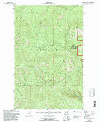
1992 Map of Jackknife Mtn
USGS Topo · Published 1996About this map
Colville National Forest dominates this topographic survey of the Kettle River Range in Ferry County, where high ridges and steep drainages define the landscape. The map centers on significant peaks including Jackknife Mtn, Mack Mountain, and Graves Mountain, with the distinctive Alligator Ridge and Twin Sisters forming prominent silhouettes against the skyline. Narrow valleys are carved by the North Fork Deadman Creek and South Fork Boulder Creek, reflecting a wilderness defined by water and altitude.
Find a feature on this map
27 named features on this map. Tap any name to fly to it.
Don’t see what you’re looking for? This feature index may not catch every label — zoom into the map to look around manually.
Map Details
Editions of this 1992 Jackknife Mtn Map
This is the sole edition of this map. No revisions or reprints were ever made.
Other maps of this area

1936 · Marcus
USGS Topo · 1:96,000

1942 · Marcus
USGS Topo · 1:125,000

1948 · Sherman Peak
USGS Topo · 1:62,500

1948 · Kettle Falls
USGS Topo · 1:62,500

1948 · Orient
USGS Topo · 1:62,500

1948 · Togo Mountain
USGS Topo · 1:62,500

1951 · Togo Mountain
USGS Topo · 1:62,500

1951 · Sherman Peak
USGS Topo · 1:62,500

1951 · Orient
USGS Topo · 1:62,500

1951 · Kettle Falls
USGS Topo · 1:62,500