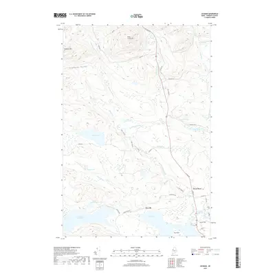
2018 Map of Jackman
USGS Topo · Published 2018About this map
Moose River and Dyerville serve as the primary points of settlement in this northern Somerset County landscape, clustered where the water systems of Wood Pond and Little Big Wood Pond converge. The topography is defined by significant elevations like Sandy Stream Mtn and the uniquely named Slidedown Mtn, which overlooks the Slidedown Valley. The map detail follows the historical corridor of the Old Canada Rd, tracing the movement of people and goods through this timber-rich region. Local history is anchored at the Holden Cem near the banks of the Moose River, while aviation history is represented by Newton Field to the south. The drainage network is particularly intricate, featuring the Heald Stream Falls and numerous smaller bodies of water such as Burnt Land Pond and Crocker Pond, illustrating a landscape shaped by glacial activity and a perennial timber economy.
Find a feature on this map
45 named features on this map. Tap any name to fly to it.
Don’t see what you’re looking for? This feature index may not catch every label — zoom into the map to look around manually.
Map Details
Editions of this 2018 Jackman Map
This is the sole edition of this map. No revisions or reprints were ever made.
Other maps of this area

1922 · Long Pond
USGS Topo · 1:62,500

1923 · Attean
USGS Topo · 1:62,500

1924 · Long Pond
USGS Topo · 1:62,500

1925 · Attean
USGS Topo · 1:62,500

1927 · Sandy Bay
USGS Topo · 1:48,000

1930 · Sandy Bay
USGS Topo · 1:62,500

1944 · Long Pond
USGS Topo · 1:62,500

1944 · Sandy Bay
USGS Topo · 1:62,500

1949 · Jackman
USGS Topo · 1:250,000

1950 · Attean
USGS Topo · 1:50,000
Featured Places
- Jackman, ME
- Moose River, ME
- Dennistown Plantation, ME
- Dyerville, Dennistown Plantation
- Attean Township, ME