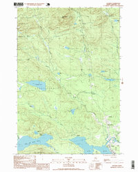
1997 Map of Jackman
USGS Topo · Published 1999About this map
Jackman serves as the focal point for this late 20th-century survey of the Maine North Woods, where the Canadian Pacific railroad tracks trace the southern edge of town near the shores of Wood Pond. The landscape is dominated by the sprawling waters of Little Big Wood Pond and Crocker Pond, reflecting a region deeply tied to timber and recreation. Local industry and infrastructure are noted through features like the Gravel Pit near Dennistown and the Sky Lodge Landing Strip further east.
Find a feature on this map
39 named features on this map. Tap any name to fly to it.
Don’t see what you’re looking for? This feature index may not catch every label — zoom into the map to look around manually.
Map Details
Editions of this 1997 Jackman Map
This is the sole edition of this map. No revisions or reprints were ever made.
Other maps of this area

1922 · Long Pond
USGS Topo · 1:62,500

1923 · Attean
USGS Topo · 1:62,500

1924 · Long Pond
USGS Topo · 1:62,500

1925 · Attean
USGS Topo · 1:62,500

1927 · Sandy Bay
USGS Topo · 1:48,000

1930 · Sandy Bay
USGS Topo · 1:62,500

1944 · Long Pond
USGS Topo · 1:62,500

1944 · Sandy Bay
USGS Topo · 1:62,500

1949 · Jackman
USGS Topo · 1:250,000

1950 · Attean
USGS Topo · 1:50,000
Featured Places
- Jackman, ME
- Moose River, ME
- Dennistown Plantation, ME
- Attean Township, ME
- Bald Mountain Township T4 R3, ME