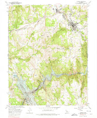
1962 Map of Jackson
USGS Topo · Published 1974About this map
Jackson stands as a central hub of activity on the Mother Lode in the early 1960s, surrounded by a landscape deeply scarred and shaped by its mining heritage. The map documents numerous iconic industrial sites, including the Kennedy Mine, Argonaut Mine, and Oneida Mine, along with lesser-known operations like the Zeile Mine and South Jackson Mine. To the south, the Mokelumne River carves a deep canyon that forms the boundary between Amador and Calaveras counties, leading into the vast expanse of the Pardee Reservoir. Infrastructure development is evident through the presence of the Amador County Airport and Pardee Dam. This survey captures a moment when the regional economy was transitioning, showing the proximity of traditional settlements like Martell and Scottsville to massive water management projects and the enduring landmarks of the gold rush era.
Find a feature on this map
92 named features on this map. Tap any name to fly to it.
Don’t see what you’re looking for? This feature index may not catch every label — zoom into the map to look around manually.
Map Details
Editions of this 1962 Jackson Map
3 editions found
Other maps of this area

1889 · Jackson
USGS Topo · 1:125,000

1892 · Jackson
USGS Topo · 1:125,000

1897 · Jackson
USGS Topo · 1:125,000

1902 · Jackson
USGS Topo · 1:125,000

1941 · Sutter Creek
USGS Topo · 1:62,500

1944 · Valley Springs
USGS Topo · 1:62,500

1944 · Sutter Creek
USGS Topo · 1:62,500

1945 · San Andreas
USGS Topo · 1:62,500

1947 · San Andreas
USGS Topo · 1:62,500

1947 · Sacramento
USGS Topo · 1:250,000