
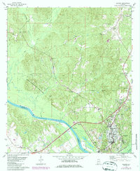
1978 Map of Jackson
USGS Topo · Published 1979About this map
The Tombigbee River forms a significant geographical boundary on this Alabama sheet, separating the town of Jackson in Clarke County from the neighboring terrain of Washington County. This late-1970s survey captures the community as a regional hub for education and industry, evidenced by the presence of institutions like Jackson Academy, Gillmore Sch, and Harper Middle Sch, alongside essential infrastructure such as a Waterworks and Pumping Station. To the west, the Upper State Game Sanctuary occupies a substantial portion of the lowlands along the river bends.
Find a feature on this map
42 named features on this map. Tap any name to fly to it.
Don’t see what you’re looking for? This feature index may not catch every label — zoom into the map to look around manually.
Map Details
Editions of this 1978 Jackson Map
2 editions found
Other maps of this area

1943 · Choctaw Bluff
USGS Topo · 1:62,500

1943 · McIntosh
USGS Topo · 1:62,500

1944 · McIntosh
USGS Topo · 1:62,500

1946 · Choctaw Bluff
USGS Topo · 1:62,500

1953 · Andalusia
USGS Topo · 1:250,000

1953 · Hattiesburg
USGS Topo · 1:250,000

1957 · Andalusia
USGS Topo · 1:250,000

1958 · Hattiesburg
USGS Topo · 1:250,000

1972 · Tattlersville
USGS Topo · 1:24,000

1972 · St. Stephens
USGS Topo · 1:24,000