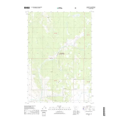
2020 Map of Jackson Hill
USGS Topo · Published 2020About this map
Beaverhead National Forest land defines this landscape in Beaverhead County, where high peaks and high-altitude meadows known as parks dominate the terrain. Significant elevations like Deer Peak and Woody Mtn tower over a complex drainage system, including Warm Springs Cr and the winding Little Milk Cr. The presence of the Jardine Ditch Number One in the south indicates the historical movement of water for agricultural or mining interests near Butch Hill. This 2020 survey details a region where road access is limited to a few primitive routes like Warm Springs Creek Rd and Woody Mountain Rd, connecting secluded locations such as Richards Park and Cox Park. The map provides a clear view of the wilderness interface between public forest lands and established surveying boundaries like t5s r14w.
Find a feature on this map
52 named features on this map. Tap any name to fly to it.
Don’t see what you’re looking for? This feature index may not catch every label — zoom into the map to look around manually.
Map Details
Editions of this 2020 Jackson Hill Map
This is the sole edition of this map. No revisions or reprints were ever made.
Other maps of this area

1955 · Dillon
USGS Topo · 1:250,000

1957 · Dillon
USGS Topo · 1:250,000

1958 · Dillon
USGS Topo · 1:250,000

1959 · Polaris
USGS Topo · 1:62,500

1962 · Dillon
USGS Topo · 1:250,000

1962 · Wisdom
USGS Topo · 1:24,000

1962 · Stewart Mountain
USGS Topo · 1:24,000

1965 · Dillon
USGS Topo · 1:250,000
1978 · Odell Lake
USGS Topo · 1:24,000
1978 · Jackson
USGS Topo · 1:24,000