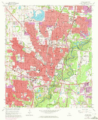
1963 Map of Jackson
USGS Topo · Published 1972About this map
The State Capitol and the downtown core of Jackson dominate this 1963 survey, revealing the city's mid-century expansion across the Pearl River into Flowood and Pearl. The map documents a dense network of educational and social institutions, from Jackson State College and the Schools for the Deaf and Blind to numerous local schools like Lanier High Sch and Brinkley High Sch. These landmarks, along with many neighborhood cemeteries including Cedar Lawn Cemetery and Elmwood Cem, offer a detailed view of the city's social geography before later urban renewal projects.
Find a feature on this map
92 named features on this map. Tap any name to fly to it.
Don’t see what you’re looking for? This feature index may not catch every label — zoom into the map to look around manually.
Map Details
Editions of this 1963 Jackson Map
3 editions found
Other maps of this area

1903 · Jackson
USGS Topo · 1:125,000

1905 · Jackson
USGS Topo · 1:48,000

1906 · Florence
USGS Topo · 1:62,500

1908 · Jackson
USGS Topo · 1:62,500

1908 · Florence
USGS Topo · 1:62,500

1934 · Raymond
USGS Topo · 1:48,000

1937 · Raymond
USGS Topo · 1:62,500

1937 · Terry
USGS Topo · 1:48,000

1942 · Raymond
USGS Topo · 1:62,500

1943 · Terry
USGS Topo · 1:62,500