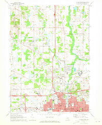
1970 Map of Jackson North
USGS Topo · Published 1973About this map
The northern reaches of Jackson and the surrounding townships of Blackman, Rives, and Tompkins are captured here during a period of significant regional infrastructure. The Southern Michigan State Prison and the expansive State Prison Farm Road area dominate the eastern portion of the map, illustrating the scale of state institutional land use at the time. To the south, the city's residential and industrial grid expands toward the Reynolds Municipal Airport, while the Penn Central and Western Trunk railroads facilitate transit through the river valleys.
Find a feature on this map
86 named features on this map. Tap any name to fly to it.
Don’t see what you’re looking for? This feature index may not catch every label — zoom into the map to look around manually.
Map Details
Editions of this 1970 Jackson North Map
2 editions found
Other maps of this area

1919 · Springport
USGS Topo · 1:62,500

1919 · Rives Junction
USGS Topo · 1:62,500

1921 · Rives Junction
USGS Topo · 1:62,500

1921 · Springport
USGS Topo · 1:62,500

1935 · Jackson
USGS Topo · 1:48,000

1939 · Jackson
USGS Topo · 1:62,500

1948 · Spring Arbor
USGS Topo · 1:62,500

1949 · Spring Arbor
USGS Topo · 1:62,500

1958 · Grand Rapids
USGS Topo · 1:250,000

1961 · Grand Rapids
USGS Topo · 1:250,000
Featured Places
- Jackson, MI
- Woodville, MI
- Rives Township, MI
- Sandstone Charter Township, MI
- Blackman Charter Township, MI