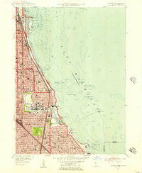
1953 Map of Jackson Park
USGS Topo · Published 1956About this map
The University of Chicago and the cultural landscape of the lakefront dominate this mid-century view of the city's south side. Significant institutions line the shore, from the Shedd Aquarium and Adler Planetarium at the northern edge down to the Museum of Science and Industry within the lagoons of Jackson Park. The map documents a period of active infrastructure development, specifically noting South Lake Shore Drive under construction south of the Midway Plaisance.
Find a feature on this map
90 named features on this map. Tap any name to fly to it.
Don’t see what you’re looking for? This feature index may not catch every label — zoom into the map to look around manually.
Map Details
Editions of this 1953 Jackson Park Map
This is the sole edition of this map. No revisions or reprints were ever made.
Other maps of this area

1889 · Chicago
USGS Topo · 1:62,500

1891 · Chicago
USGS Topo · 1:62,500

1892 · Calumet
USGS Topo · 1:62,500

1893 · Calumet
USGS Topo · 1:62,500

1900 · Chicago
USGS Topo · 1:62,500

1900 · Toleston
USGS Topo · 1:62,500

1900 · Calumet
USGS Topo · 1:62,500

1901 · Calumet
USGS Topo · 1:62,500

1901 · Chicago
USGS Topo · 1:62,500

1929 · Calumet Lake
USGS Topo · 1:24,000