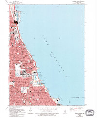
1993 Map of Jackson Park
USGS Topo · Published 1993About this map
The Lake Michigan shoreline defines the eastern reach of Chicago in the early 1990s, revealing a dense urban landscape of world-renowned institutions and historic South Side neighborhoods. Large civic green spaces like Grant Park and Jackson Park anchor the lakefront, containing the Museum of Science and Industry, the Shedd Aquarium, and the Adler Planetarium. This map documents the complex infrastructure of a modern metropolis, from the Chicago Skyway (Toll) to the Illinois Central Gulf RR corridor. Further inland, the sprawling grounds of the University of Chicago and Oakwoods Cemetery stand as massive anchors for their respective districts. The map shows the intricate network of harbor systems, including Burnham Park Harbor and the 59th Street Harbor, protected by a continuous Seawall and the Southerly Breakwater.
Find a feature on this map
82 named features on this map. Tap any name to fly to it.
Don’t see what you’re looking for? This feature index may not catch every label — zoom into the map to look around manually.
Map Details
Editions of this 1993 Jackson Park Map
This is the sole edition of this map. No revisions or reprints were ever made.
Other maps of this area

1889 · Chicago
USGS Topo · 1:62,500

1891 · Chicago
USGS Topo · 1:62,500

1892 · Calumet
USGS Topo · 1:62,500

1893 · Calumet
USGS Topo · 1:62,500

1900 · Chicago
USGS Topo · 1:62,500

1900 · Toleston
USGS Topo · 1:62,500

1900 · Calumet
USGS Topo · 1:62,500

1901 · Calumet
USGS Topo · 1:62,500

1901 · Chicago
USGS Topo · 1:62,500

1929 · Calumet Lake
USGS Topo · 1:24,000