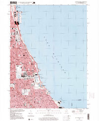
1998 Map of Jackson Park
USGS Topo · Published 1999About this map
Lake Michigan dominates the eastern half of this urban landscape, where the meticulously planned waterfront of South Side Chicago meets the shoreline. The lakefront is defined by a continuous chain of public spaces and cultural institutions, from the northern reach of Grant Park down to the sprawling Jackson Park. This survey captures the area just before the closure of Meigs Field, showing the airport on Northerly Island alongside the Adler Planetarium and Shedd Aquarium.
Find a feature on this map
95 named features on this map. Tap any name to fly to it.
Don’t see what you’re looking for? This feature index may not catch every label — zoom into the map to look around manually.
Map Details
Editions of this 1998 Jackson Park Map
This is the sole edition of this map. No revisions or reprints were ever made.
Other maps of this area

1889 · Chicago
USGS Topo · 1:62,500

1891 · Chicago
USGS Topo · 1:62,500

1892 · Calumet
USGS Topo · 1:62,500

1893 · Calumet
USGS Topo · 1:62,500

1900 · Chicago
USGS Topo · 1:62,500

1900 · Toleston
USGS Topo · 1:62,500

1900 · Calumet
USGS Topo · 1:62,500

1901 · Calumet
USGS Topo · 1:62,500

1901 · Chicago
USGS Topo · 1:62,500

1929 · Calumet Lake
USGS Topo · 1:24,000