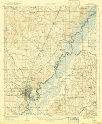
1908 Map of Jackson
USGS Topo · Published 1943About this map
The Jackson urban center dominates the southwestern quadrant of this 1908-era survey, showing the city's early development at the junction of five major railroads including the Illinois Central RR and the Alabama and Vicksburg RR. Notable institutional landmarks like the Insane Asylum and Orphanage stand on the city's northern outskirts, near the developing community at Asylum. To the north, the landscape transitions into the Black Prairie region, where the Pearl River meanders toward the Johnson Ferry (Abandoned). The map documents a rural society anchored by local industry and education, featuring Tougaloo University, McGuffins Mill, and the Madison Station rail stop. Settlement patterns follow the high ground between creek drainages like Hanging Moss Creek and Pelahatchie Creek, marked by numerous country churches such as Whiteoak Church and China Grove Church.
Find a feature on this map
72 named features on this map. Tap any name to fly to it.
Don’t see what you’re looking for? This feature index may not catch every label — zoom into the map to look around manually.
Map Details
Editions of this 1908 Jackson Map
2 editions found
Other maps of this area

1903 · Jackson
USGS Topo · 1:125,000

1905 · Jackson
USGS Topo · 1:48,000

1906 · Florence
USGS Topo · 1:62,500

1908 · Jackson
USGS Topo · 1:62,500

1908 · Florence
USGS Topo · 1:62,500

1922 · Pelahatchee
USGS Topo · 1:48,000

1924 · Pelahatchee
USGS Topo · 1:62,500

1934 · Raymond
USGS Topo · 1:48,000

1937 · Raymond
USGS Topo · 1:62,500

1937 · Terry
USGS Topo · 1:48,000