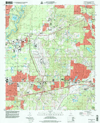
1998 Map of Jackson SE
USGS Topo · Published 1998About this map
Jackson International Airport anchors the central landscape of this Rankin County survey, reflecting the suburban expansion east of the Pearl River at the close of the century. The map illustrates a complex network of municipal boundaries, including the Flowood and Jackson corporate boundaries, which intersect near the sprawling medical and educational facilities like River Oaks Hospital and Hinds Community College. Beyond the modern infrastructure, the terrain is marked by numerous sand and clay excavations, such as the Sandpits and Clay Pits near Jackson, indicating the regional reliance on local geological resources.
Find a feature on this map
67 named features on this map. Tap any name to fly to it.
Don’t see what you’re looking for? This feature index may not catch every label — zoom into the map to look around manually.
Map Details
Editions of this 1998 Jackson SE Map
This is the sole edition of this map. No revisions or reprints were ever made.
Other maps of this area

1903 · Jackson
USGS Topo · 1:125,000

1905 · Jackson
USGS Topo · 1:48,000

1906 · Florence
USGS Topo · 1:62,500

1908 · Jackson
USGS Topo · 1:62,500

1908 · Florence
USGS Topo · 1:62,500

1922 · Pelahatchee
USGS Topo · 1:48,000

1924 · Pelahatchee
USGS Topo · 1:62,500

1950 · Pelahatchie
USGS Topo · 1:62,500

1952 · Pelahatchie
USGS Topo · 1:62,500

1953 · Meridian
USGS Topo · 1:250,000