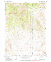
1967 Map of Jackson Spring
USGS Topo · Published 1983About this map
Tecoma Valley defines the southern portion of this high-desert survey, where the border between Nevada and Utah meets the county line for Elko and Box Elder. The landscape is marked by the vital presence of water in an arid environment, featuring Jackson Spring, Kilgore Spring, and several other unnamed Springs. These water sources likely dictated the movement of early travelers and miners through the region. Industrial activity is concentrated at the Jackson Mines, tucked into the higher elevations. A network of Jeep Trails provides the primary means of navigating the terrain, connecting the mineral prospects and water sources to the broader valley. A solitary Well and a Borrow Pit further indicate the sparse but intentional human imprint on this borderland territory during the late 1960s.
Find a feature on this map
11 named features on this map. Tap any name to fly to it.
Don’t see what you’re looking for? This feature index may not catch every label — zoom into the map to look around manually.
Map Details
Editions of this 1967 Jackson Spring Map
2 editions found
Other maps of this area

1954 · Brigham City
USGS Topo · 1:250,000

1955 · Wells
USGS Topo · 1:250,000

1958 · Wells
USGS Topo · 1:250,000

1958 · Brigham City
USGS Topo · 1:250,000

1961 · Wells
USGS Topo · 1:250,000

1961 · Dairy Valley
USGS Topo · 1:62,500

1962 · Brigham City
USGS Topo · 1:250,000

1967 · Jackson Spring
USGS Topo · 1:24,000

1967 · Lucin
USGS Topo · 1:24,000

1967 · Twelvemile Ranch
USGS Topo · 1:24,000