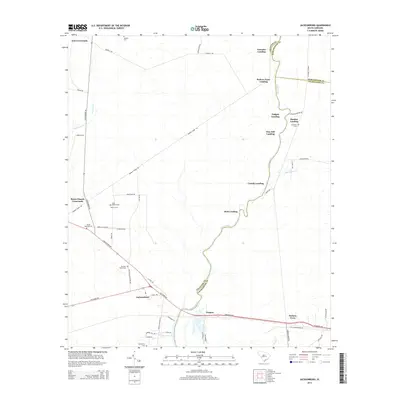
2014 Map of Jacksonboro
USGS Topo · Published 2014About this map
The Edisto River winds through this coastal South Carolina landscape, serving as a boundary for Colleton Co, Dorchester Co, and Charleston Co. Along its banks, numerous landings such as Lowndes Landing, Parkers Ferry Landing, and Martins Landing highlight the historical reliance on water-based transport and regional commerce. Inland, the settlement of Jacksonboro sits near the intersection of the ACE Basin Pky and Savannah Hwy, while smaller communities like Ponpon and Parkers Ferry dot the southern reaches. Local history is deeply embedded in the land, evidenced by sites like the Isaac Hayne Tomb and Haynes Cem, alongside the descriptively named Burnt Church Crossroads. The map traces a network of plantation-era thoroughfares, including Pon Pon Plantation Ave and Hope Plantation Ln, which connect the scattered homesteads and cemeteries across the riverine terrain.
Find a feature on this map
57 named features on this map. Tap any name to fly to it.
Don’t see what you’re looking for? This feature index may not catch every label — zoom into the map to look around manually.
Map Details
Editions of this 2014 Jacksonboro Map
This is the sole edition of this map. No revisions or reprints were ever made.
Other maps of this area

1918 · Walterboro
USGS Topo · 1:62,500

1918 · Green Pond
USGS Topo · 1:62,500

1918 · Cottageville
USGS Topo · 1:62,500

1919 · Edisto Island
USGS Topo · 1:62,500

1943 · Cottageville
USGS Topo · 1:62,500

1943 · Edisto Island
USGS Topo · 1:62,500

1943 · Green Pond
USGS Topo · 1:62,500

1943 · Walterboro
USGS Topo · 1:62,500

1947 · Savannah
USGS Topo · 1:250,000

1948 · Savannah
USGS Topo · 1:250,000