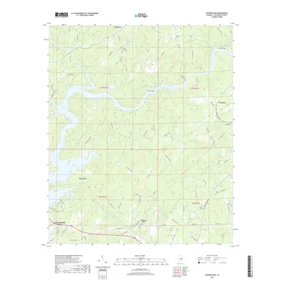
2018 Map of Jacksons Gap
USGS Topo · Published 2018About this map
The Tallapoosa River winds through this landscape, feeding the expansive waters of Martin Lake and shaping the development of northeastern Tallapoosa County. This 2018 survey captures the region long after the river was harnessed, showing a mixture of lakeside recreation and established rural communities. The settlement of Jacksons Gap serves as a local hub near the southern edge, while the northeastern corner includes the historic vicinity of Tohopeka, situated along the bend of the river. Small family and community burial grounds, such as Jackson Field Cem and Woods Cem, are scattered across the terrain, providing essential data for genealogical research. The map also documents the transition from the industrial outskirts of Alexander City to the more dispersed settlements of Fosheeton and Sturdivant, connected by a network of rural routes like Horseshoe Bend Rd and Fox Creek Rd.
Find a feature on this map
93 named features on this map. Tap any name to fly to it.
Don’t see what you’re looking for? This feature index may not catch every label — zoom into the map to look around manually.
Map Details
Editions of this 2018 Jacksons Gap Map
This is the sole edition of this map. No revisions or reprints were ever made.
Other maps of this area

1891 · Ashland
USGS Topo · 1:125,000

1906 · Dadeville
USGS Topo · 1:125,000

1953 · Atlanta
USGS Topo · 1:250,000

1955 · Phenix City
USGS Topo · 1:250,000

1957 · Phenix City
USGS Topo · 1:250,000

1957 · Atlanta
USGS Topo · 1:250,000

1958 · Phenix City
USGS Topo · 1:250,000

1958 · Atlanta
USGS Topo · 1:250,000

1969 · New Site
USGS Topo · 1:24,000
1969 · Hackneyville
USGS Topo · 1:24,000