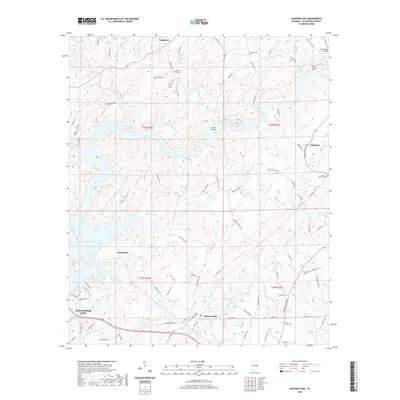
2020 Map of Jacksons Gap
USGS Topo · Published 2020About this map
Martin Lake and the Tallapoosa River dominate this portion of Tallapoosa County, illustrating a landscape defined by the transition from riverine shoals to significant reservoir waters. The small settlement of Jacksons Gap serves as a central point for a network of local roads and trails, including Horseshoe Bend Rd and Grimes Ferry Rd. This survey preserves the locations of numerous family and community landmarks, such as Antioch Cem, Ephesus Cem, and Jackson Field Cem, which are essential for genealogical research in the area. Upstream, the Hamlet Mill Bridge crosses Emuckfaw Creek near Peters Island, while Irwin Shoals marks a distinct point on the river before it widens. Smaller communities like Sturdivant, Fosheeton, and Tohopeka are interconnected by historically significant routes like Old Hickory Rd and Andrew Jackson Rd.
Find a feature on this map
89 named features on this map. Tap any name to fly to it.
Don’t see what you’re looking for? This feature index may not catch every label — zoom into the map to look around manually.
Map Details
Editions of this 2020 Jacksons Gap Map
This is the sole edition of this map. No revisions or reprints were ever made.
Other maps of this area

1891 · Ashland
USGS Topo · 1:125,000

1906 · Dadeville
USGS Topo · 1:125,000

1953 · Atlanta
USGS Topo · 1:250,000

1955 · Phenix City
USGS Topo · 1:250,000

1957 · Phenix City
USGS Topo · 1:250,000

1957 · Atlanta
USGS Topo · 1:250,000

1958 · Phenix City
USGS Topo · 1:250,000

1958 · Atlanta
USGS Topo · 1:250,000

1969 · New Site
USGS Topo · 1:24,000
1969 · Hackneyville
USGS Topo · 1:24,000