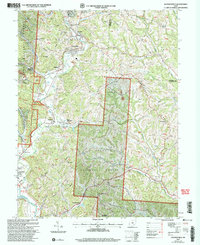
2002 Map of Jacksonville
USGS Topo · Published 2006About this map
Wayne National Forest dominates the rugged topography of this region, where the industrial legacy of the Hocking Valley coal fields meets modern conservation. The landscape is defined by the winding course of Sunday Creek, which connects a string of historic mining and railroad communities including Glouster, Trimble, Jacksonville, and Millfield. Evidence of the area's extraction history is visible through labels for strip mines and a tipple, contrasting with the numerous country churches and burial grounds like Queen of Heaven Cem and Liberty Hill Ch Cem that dot the ridges. To the south, the Hocking River cuts through the terrain near Chauncey, providing a natural corridor through the hills of Athens and Morgan counties. The map captures a transition period in the early 21st century, documenting Forest Service roads and established settlements alongside family landmarks like Brown Cem and Taylor Ridge.
Find a feature on this map
72 named features on this map. Tap any name to fly to it.
Don’t see what you’re looking for? This feature index may not catch every label — zoom into the map to look around manually.
Map Details
Editions of this 2002 Jacksonville Map
This is the sole edition of this map. No revisions or reprints were ever made.
Other maps of this area

1903 · Athens
USGS Topo · 1:62,500

1904 · Chesterhill
USGS Topo · 1:62,500

1905 · Athens
USGS Topo · 1:62,500

1906 · Chesterhill
USGS Topo · 1:62,500

1910 · Mc Connelsville
USGS Topo · 1:62,500

1911 · New Lexington
USGS Topo · 1:62,500

1947 · Columbus
USGS Topo · 1:250,000

1949 · Clarksburg
USGS Topo · 1:250,000

1956 · Clarksburg
USGS Topo · 1:250,000

1960 · Amesville
USGS Topo · 1:24,000