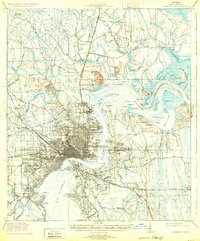
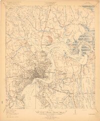
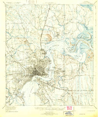
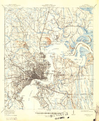
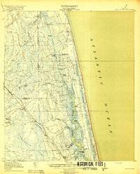
1918 Map of Jacksonville
USGS Topo · Published 1932About this map
The St Johns River serves as the dominant artery for this 1917 survey of Duval County, revealing a bustling port city defined by its waterfront industry and expanding rail networks. The dense urban core of Jacksonville is surrounded by emerging suburbs and landings such as Brooklyn, South Jacksonville, and Ortega. The presence of the City Prison Farm near Trout River and the County Prison Farm further south reflects the institutional layout of the era. North of the city, the landscape transitions into a network of creeks and marshes, with small communities like New Berlin and Eastport situated near Dunn Creek. Significant infrastructure of the period is visible through the Seaboard Air Line Railroad and Florida East Coast Railway, which catalyzed the growth of neighborhoods like Murray Hill and Grand Crossing. Local education and social life are anchored by landmarks like the Otto Chapel School and Flagler Preparatory School, providing clear points of interest for genealogical research.
Find a feature on this map
104 named features on this map. Tap any name to fly to it.
Don’t see what you’re looking for? This feature index may not catch every label — zoom into the map to look around manually.
Map Details
Editions of this 1918 Jacksonville Map
5 editions found
Other maps of this area

1917 · Orange Park
USGS Topo · 1:62,500

1917 · Cambon
USGS Topo · 1:62,500

1917 · Hilliard
USGS Topo · 1:62,500

1918 · St Marys
USGS Topo · 1:62,500

1918 · Middleburg
USGS Topo · 1:62,500

1918 · Cambon
USGS Topo · 1:62,500

1918 · Jacksonville
USGS Topo · 1:62,500

1918 · Orange Park
USGS Topo · 1:62,500
1918 · Palm Valley
USGS Topo · 1:62,500
1918 · Mayport
USGS Topo · 1:62,500
Featured Places
- Jacksonville, FL
- Holiday Hill, Jacksonville
- Lake Park Estates, Jacksonville
- Lake Shore, Jacksonville
- Pearl Court, Jacksonville