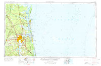
1957 Map of Jacksonville
USGS Topo · Published 1974About this map
The St Johns River serves as the central artery for this mid-century portrait of Northeast Florida and Southeast Georgia, anchoring a landscape defined by military readiness and coastal commerce. The expansion of Jacksonville is evident alongside established naval installations such as NAS Jacksonville, NAS Cecil, and the Kings Bay Ammunition Terminal. The intricate maritime network is traced through the Intracoastal Waterway and the St Marys River, which separates the two states.
Find a feature on this map
168 named features on this map. Tap any name to fly to it.
Don’t see what you’re looking for? This feature index may not catch every label — zoom into the map to look around manually.
Map Details
Editions of this 1957 Jacksonville Map
3 editions found

Other maps of this area

1917 · Orange Park
USGS Topo · 1:62,500

1917 · Nahunta
USGS Topo · 1:62,500

1917 · Cambon
USGS Topo · 1:62,500

1917 · Boulogne
USGS Topo · 1:62,500

1917 · Macclenny
USGS Topo · 1:62,500

1917 · Hilliard
USGS Topo · 1:62,500

1918 · St Marys
USGS Topo · 1:62,500

1918 · Cumberland Island
USGS Topo · 1:62,500

1918 · Folkston
USGS Topo · 1:62,500

1918 · Middleburg
USGS Topo · 1:62,500