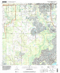
1994 Map of Jacksonville Heights
USGS Topo · Published 2002About this map
US Naval Air Station (Cecil Field) dominates the western landscape of this 1990s Florida survey, marking a period of significant military presence and transition in the region. The map captures the suburban expansion of Jacksonville south into Clay County, where residential developments like Westwood and Enchanted Park push against preserved natural areas. The Jennings State Forest and the Branan Field Wildlife and Environmental Area Mitigation Park offer a contrast to the dense grid of streets further north in Jacksonville Heights. Researchers will find numerous community landmarks including the N B Forrest High Sch and Federal Hill Cem. Waterways such as the Ortega River and South Prong define the drainage patterns, eventually leading toward Doctors Lake and Sugarhouse Cove in the southeast corner. Traces of older transport are visible in the Old Railroad Grade running near the northern boundary.
Find a feature on this map
62 named features on this map. Tap any name to fly to it.
Don’t see what you’re looking for? This feature index may not catch every label — zoom into the map to look around manually.
Map Details
Editions of this 1994 Jacksonville Heights Map
This is the sole edition of this map. No revisions or reprints were ever made.
Other maps of this area

1917 · Orange Park
USGS Topo · 1:62,500

1917 · Cambon
USGS Topo · 1:62,500

1918 · Middleburg
USGS Topo · 1:62,500

1918 · Cambon
USGS Topo · 1:62,500

1918 · Jacksonville
USGS Topo · 1:62,500

1918 · Orange Park
USGS Topo · 1:62,500

1941 · Middleburg
USGS Topo · 1:62,500

1948 · Jacksonville
USGS Topo · 1:250,000

1949 · Middleburg SW
USGS Topo · 1:24,000

1949 · Fiftone
USGS Topo · 1:24,000
Featured Places
- Jacksonville, FL
- Oak Hill, Jacksonville
- Westwood, Jacksonville
- Oak Hill Park, Jacksonville
- Ridgewood, FL