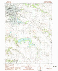
1983 Map of Jacksonville
USGS Topo · Published 1983About this map
The civic and educational core of Jacksonville dominates the northern half of this 1983 map, defined by a concentration of historic institutions. The city's landscape is shaped by the presence of Illinois College and MacMurray College, alongside specialized facilities like the Illinois Sch for the Visually Impaired and the Mental Health and Development Center. As the county seat of Morgan Co. , the town shows a mature infrastructure of public schools, including Lincoln Sch, and multiple religious and memorial sites such as Our Savior Parish Sch and East Cem.
Find a feature on this map
54 named features on this map. Tap any name to fly to it.
Don’t see what you’re looking for? This feature index may not catch every label — zoom into the map to look around manually.
Map Details
Editions of this 1983 Jacksonville Map
This is the sole edition of this map. No revisions or reprints were ever made.
Other maps of this area

1924 · Winchester
USGS Topo · 1:48,000

1926 · Winchester
USGS Topo · 1:62,500

1929 · Arenzville
USGS Topo · 1:62,500

1932 · Arenzville
USGS Topo · 1:62,500

1932 · Jacksonville
USGS Topo · 1:62,500

1932 · Virginia
USGS Topo · 1:62,500

1936 · Virginia
USGS Topo · 1:62,500

1937 · Jacksonville
USGS Topo · 1:62,500

1948 · Quincy
USGS Topo · 1:250,000

1956 · Quincy
USGS Topo · 1:250,000