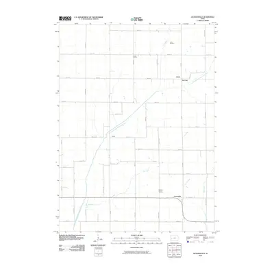
2010 Map of Jacksonville
USGS Topo · Published 2010About this map
Jacksonville sits at the heart of this Shelby County landscape, where the rural character of western Iowa is defined by a rigorous section-line road grid and a network of wandering waterways. The East Branch West Nishnabotna River meanders through the central terrain, joined by several smaller tributaries including Elm Creek, Bonnie Creek, and Wolf Creek. This area preserves several historical touchstones for genealogists, with long-established burial grounds like Poplar Cemetery, Danway Cemetery, and the Bethlehem Lutheran Cemetery scattered among the farmsteads.
Find a feature on this map
36 named features on this map. Tap any name to fly to it.
Don’t see what you’re looking for? This feature index may not catch every label — zoom into the map to look around manually.
Map Details
Editions of this 2010 Jacksonville Map
This is the sole edition of this map. No revisions or reprints were ever made.
Other maps of this area

1954 · Omaha
USGS Topo · 1:250,000

1957 · Omaha
USGS Topo · 1:250,000

1958 · Omaha
USGS Topo · 1:250,000

1971 · Defiance
USGS Topo · 1:24,000

1978 · Elk Horn
USGS Topo · 1:24,000

1978 · Irwin
USGS Topo · 1:24,000

1978 · Kimballton
USGS Topo · 1:24,000

1978 · Corley
USGS Topo · 1:24,000

1978 · Prairie Rose Lake
USGS Topo · 1:24,000
1978 · Harlan
USGS Topo · 1:24,000