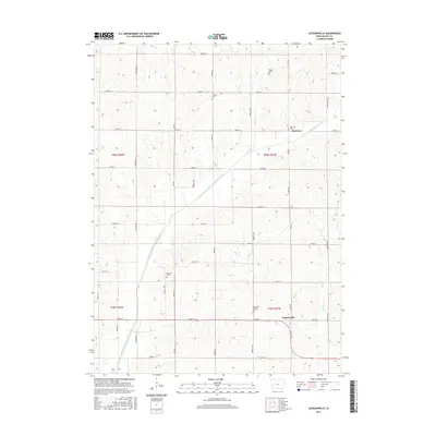
2015 Map of Jacksonville
USGS Topo · Published 2015About this map
Jacksonville and the small settlement of Red Line serve as the primary human touchpoints in this section of Shelby County. The landscape is defined by the winding course of the East Branch West Nishnabotna River, which is fed by numerous tributaries including Elm Cr, Bonnie Cr, and Wolf Cr. The map reveals a deeply established rural grid, where family history is anchored by several distinct burial grounds such as Bethlehem Lutheran Cem, Red Line Cem, and Danway Cem.
Find a feature on this map
44 named features on this map. Tap any name to fly to it.
Don’t see what you’re looking for? This feature index may not catch every label — zoom into the map to look around manually.
Map Details
Editions of this 2015 Jacksonville Map
This is the sole edition of this map. No revisions or reprints were ever made.
Other maps of this area

1954 · Omaha
USGS Topo · 1:250,000

1957 · Omaha
USGS Topo · 1:250,000

1958 · Omaha
USGS Topo · 1:250,000

1971 · Defiance
USGS Topo · 1:24,000

1978 · Elk Horn
USGS Topo · 1:24,000

1978 · Irwin
USGS Topo · 1:24,000

1978 · Kimballton
USGS Topo · 1:24,000

1978 · Corley
USGS Topo · 1:24,000

1978 · Prairie Rose Lake
USGS Topo · 1:24,000
1978 · Harlan
USGS Topo · 1:24,000