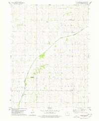
1978 Map of Jacksonville
USGS Topo · Published 1978About this map
Jacksonville sits at the intersection of a sprawling rural landscape defined by the winding course of the West Nishnabotna River and its numerous tributaries. Surveyed in the late 1970s, the map reveals a highly structured agricultural grid across Douglas, Polk, Jackson, and Center townships. Local social life is anchored by small community landmarks like the Community Hall and Community Center, alongside the Bethlehem Ch. The terrain is deeply dissected by drainage systems including Wolf Creek, Bonnie Creek, and Elm Creek, which dictate the placement of farmsteads and rural roads. Genealogists can locate legacy sites such as Danway Cem and Bowmans Grove Cem, which serve as quiet markers of the area's early settlement history. The presence of the small community of Red Line near the East Branch West Nishnabotna River further illustrates the localized settlement patterns of Shelby County.
Find a feature on this map
18 named features on this map. Tap any name to fly to it.
Don’t see what you’re looking for? This feature index may not catch every label — zoom into the map to look around manually.
Map Details
Editions of this 1978 Jacksonville Map
This is the sole edition of this map. No revisions or reprints were ever made.
Other maps of this area

1954 · Omaha
USGS Topo · 1:250,000

1957 · Omaha
USGS Topo · 1:250,000

1958 · Omaha
USGS Topo · 1:250,000

1971 · Defiance
USGS Topo · 1:24,000

1978 · Elk Horn
USGS Topo · 1:24,000

1978 · Irwin
USGS Topo · 1:24,000

1978 · Kimballton
USGS Topo · 1:24,000

1978 · Corley
USGS Topo · 1:24,000

1978 · Prairie Rose Lake
USGS Topo · 1:24,000
1978 · Harlan
USGS Topo · 1:24,000