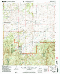
2004 Map of Jacob Spring
USGS Topo · Published 2006About this map
Lincoln National Forest land dominates the lower half of this landscape, where the northern slopes of the Capitan Mountains meet high-desert ranching country. The terrain is defined by a series of north-trending drainage systems, including Patos Creek and Carrizo Creek, which cut through broad flats like Texas Park. Cattle ranching history is etched into the map through numerous named stock watering points such as Ten Dollar Tank, Blind Tank, and Bear Tank, supporting operations at Leslie Ranch, Lacey Ranch, and Waddell Ranch. Evidence of earlier resource extraction is noted at the Iron Mine Tank near the southern boundary. To the north, Patos Road and Bogle Road provide the primary transit through the canyons, while the eponymous Jacob Spring sits nestled near the intersection of several deep ravines.
Find a feature on this map
37 named features on this map. Tap any name to fly to it.
Don’t see what you’re looking for? This feature index may not catch every label — zoom into the map to look around manually.
Map Details
Editions of this 2004 Jacob Spring Map
This is the sole edition of this map. No revisions or reprints were ever made.
Other maps of this area

1934 · Capitan
USGS Topo · 1:48,000

1935 · Capitan Mountains
USGS Topo · 1:48,000

1937 · Capitan
USGS Topo · 1:62,500

1940 · Capitan Mountains
USGS Topo · 1:62,500

1955 · Roswell
USGS Topo · 1:250,000

1958 · Roswell
USGS Topo · 1:250,000

1962 · Roswell
USGS Topo · 1:250,000

1973 · Jacob Spring
USGS Topo · 1:24,000
1973 · Nogal
USGS Topo · 1:24,000
1973 · White Oaks North
USGS Topo · 1:24,000