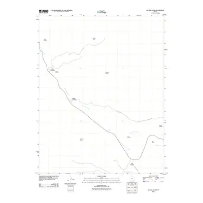
2011 Map of Jacobs Chair
USGS Topo · Published 2011About this map
White Canyon Creek carves a deep path through this southeastern Utah landscape, providing a geographical anchor for historical transit routes. In the early 21st century, the area remains defined by its namesake landmark Jacobs Chair and several notable transit points along the drainage. Small settlements and waypoints like Soldier Crossing and Gravel Crossing mark where travelers and commerce historically navigated the drainage, while the presence of Radium King Rd hints at the region's mid-century uranium mining legacy. High plateaus and isolated landforms such as Wingate Mesa and Fry Point dominate the horizon, framing the deep incisions of Cowboy Canyon and Long Canyon. The small community at Fry Canyon serves as a lone outpost in this expansive high-desert terrain, positioned where the terrain transitions toward the rugged mesas of San Juan County.
Find a feature on this map
16 named features on this map. Tap any name to fly to it.
Don’t see what you’re looking for? This feature index may not catch every label — zoom into the map to look around manually.
Map Details
Editions of this 2011 Jacobs Chair Map
This is the sole edition of this map. No revisions or reprints were ever made.
Other maps of this area

1886 · Henry Mountains
USGS Topo · 1:250,000

1892 · Henry Mountains
USGS Topo · 1:250,000

1952 · Mouth of Dark Canyon
USGS Topo · 1:62,500

1952 · Mancos Mesa
USGS Topo · 1:62,500

1952 · Natural Bridges
USGS Topo · 1:62,500

1952 · Hite
USGS Topo · 1:62,500

1954 · White Canyon 3 SE
USGS Topo · 1:24,000

1954 · White Canyon 4 NE
USGS Topo · 1:24,000

1954 · White Canyon 4 SE
USGS Topo · 1:24,000
1954 · White Canyon 1 SE
USGS Topo · 1:24,000