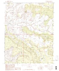
1987 Map of Jacobs Chair
USGS Topo · Published 1987About this map
Jacobs Chair stands as the defining landmark of this high-desert landscape in southeastern Utah, where the deep incisions of White Canyon and Fry Canyon dictate the movement of travelers and water. By the late 1980s, the area's geography was defined by massive sandstone features such as Wingate Mesa and Found Mesa, while human activity is evidenced by scattered Prospect sites and the presence of a Landing Strip. The map records historical route points like Soldier Crossing and Gravel Crossing, which mark where early travelers and modern 4WD vehicles navigated the canyon bottoms. Near the confluence of these drainages, the Fry Canyon Trailer Park provides a rare point of habitation in a region characterized by its expansive mesas and steep-walled canyons, including Cowboy Canyon and Nook Canyon.
Find a feature on this map
17 named features on this map. Tap any name to fly to it.
Don’t see what you’re looking for? This feature index may not catch every label — zoom into the map to look around manually.
Map Details
Editions of this 1987 Jacobs Chair Map
This is the sole edition of this map. No revisions or reprints were ever made.
Other maps of this area

1886 · Henry Mountains
USGS Topo · 1:250,000

1892 · Henry Mountains
USGS Topo · 1:250,000

1952 · Mouth of Dark Canyon
USGS Topo · 1:62,500

1952 · Mancos Mesa
USGS Topo · 1:62,500

1952 · Natural Bridges
USGS Topo · 1:62,500

1952 · Hite
USGS Topo · 1:62,500

1954 · White Canyon 3 SE
USGS Topo · 1:24,000

1954 · White Canyon 4 NE
USGS Topo · 1:24,000

1954 · White Canyon 4 SE
USGS Topo · 1:24,000
1954 · White Canyon 1 SE
USGS Topo · 1:24,000