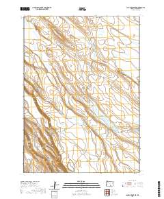
2020 Map of Jacobs Reservoir
USGS Topo · Published 2020About this map
Guano Cr winds through this high-desert landscape of Lake County, defining a complex drainage system that feeds numerous seasonal catchments and named pools. The area is characterized by an extensive network of reservoirs and waterholes, such as O'Keefe Reservoir, Handle Reservoir, and Jacobs Reservoir, which were essential for managing water in this arid stretch of the Oregon outback. The terrain shifts from open expanses like Wire Corral Flat and Spanish Flat to the more structured landforms of Cat Butte and the depressions of Clover Swale. This 2020 map documents a landscape of essential resource management, where water bodies like School Section Lake and Wildlife Lake provide critical points of interest across the township lines of the High Desert. The distribution of these water features, including Billy Burr Lake and Fortyfour Lake, illustrates the continuing importance of localized water storage for ranching and wildlife in the region.
Find a feature on this map
31 named features on this map. Tap any name to fly to it.
Don’t see what you’re looking for? This feature index may not catch every label — zoom into the map to look around manually.
Map Details
Editions of this 2020 Jacobs Reservoir Map
This is the sole edition of this map. No revisions or reprints were ever made.
Other maps of this area

1955 · Adel
USGS Topo · 1:250,000

1957 · Adel
USGS Topo · 1:250,000

1958 · Adel
USGS Topo · 1:250,000

1962 · Adel
USGS Topo · 1:250,000

1967 · Jacobs Reservoir
USGS Topo · 1:24,000

1967 · Alger Lake
USGS Topo · 1:24,000

1967 · Hart Lake
USGS Topo · 1:24,000

1967 · Warner Peak
USGS Topo · 1:24,000

1967 · Swede Knoll
USGS Topo · 1:24,000

1967 · Crump Lake
USGS Topo · 1:24,000