
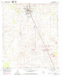
1969 Map of Jal
USGS Topo · Published 1972About this map
The town of Jal serves as the central hub of this late-1960s desert landscape, positioned at the intersection of a significant pipeline and rail network. The Texas New Mexico railroad line cuts a sharp diagonal across the arid terrain, reflecting the industrial priorities of the Permian Basin. This energy-focused economy is further evidenced by the numerous Gravel Pits and gravel extractions scattered throughout the region.
Find a feature on this map
14 named features on this map. Tap any name to fly to it.
Don’t see what you’re looking for? This feature index may not catch every label — zoom into the map to look around manually.
Map Details
Editions of this 1969 Jal Map
2 editions found
Other maps of this area

1954 · Hobbs
USGS Topo · 1:250,000

1954 · Pecos
USGS Topo · 1:250,000

1957 · Pecos
USGS Topo · 1:250,000

1958 · Hobbs
USGS Topo · 1:250,000

1969 · Jal NE
USGS Topo · 1:24,000

1969 · Jal NW
USGS Topo · 1:24,000

1969 · Jal SE
USGS Topo · 1:24,000

1970 · Cheyenne Draw
USGS Topo · 1:24,000

1970 · Vesrue
USGS Topo · 1:24,000

1970 · Kermit NW
USGS Topo · 1:24,000