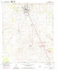
1969 Map of Jal
USGS Topo · Published 1980About this map
The high plains of the Permian Basin define this landscape, where the town of Jal serves as a hub for the region's intensive energy infrastructure. Situated just north of the Texas border in Lea County, the town's development is closely tied to the surrounding oil fields, evidenced by the dense network of pipelines and scattered Oil Wells across the Monument and Jal Hollow terrain. Local life in the late 1960s is reflected in the presence of the High Sch, Burke Jr High Sch, and a Drive-in Theater on the southern edge of town.
Find a feature on this map
21 named features on this map. Tap any name to fly to it.
Don’t see what you’re looking for? This feature index may not catch every label — zoom into the map to look around manually.
Map Details
Editions of this 1969 Jal Map
2 editions found
Other maps of this area

1954 · Hobbs
USGS Topo · 1:250,000

1954 · Pecos
USGS Topo · 1:250,000

1957 · Pecos
USGS Topo · 1:250,000

1958 · Hobbs
USGS Topo · 1:250,000

1969 · Jal NE
USGS Topo · 1:24,000

1969 · Jal NW
USGS Topo · 1:24,000

1969 · Jal
USGS Topo · 1:24,000

1969 · Jal SE
USGS Topo · 1:24,000

1970 · Cheyenne Draw
USGS Topo · 1:24,000

1970 · Vesrue
USGS Topo · 1:24,000