
1969 Map of Jal SE
USGS Topo · Published 1973About this map
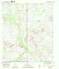
Dollarhide Oil Field dominates the northern landscape of this Permian Basin survey, where the borders of Lea and Andrews counties meet at the New Mexico-Texas line. The terrain is defined by the broad, low depression of Monument Draw, which runs north-to-south through a landscape of scrub and desert features. To the east, the ground rises into areas of Shifting Sand, illustrating the active eolian processes of the High Plains. Industrial development is evident throughout the region, with an extensive network of pipelines and scattered oil wells servicing the energy infrastructure. Human activity in this arid environment is further marked by a lone Corral and several gravel pits. A network of primitive roads, including a labeled Jeep Trail, provides the primary means of navigating the undulating sandy terrain between the major oil production zones.
Find a feature on this map
14 named features on this map. Tap any name to fly to it.
Don’t see what you’re looking for? This feature index may not catch every label — zoom into the map to look around manually.
Map Details
Editions of this 1969 Jal SE Map
2 editions found
Other maps of this area

1954 · Hobbs
USGS Topo · 1:250,000

1954 · Pecos
USGS Topo · 1:250,000

1957 · Pecos
USGS Topo · 1:250,000

1958 · Hobbs
USGS Topo · 1:250,000

1969 · Jal NE
USGS Topo · 1:24,000

1969 · Jal NW
USGS Topo · 1:24,000

1969 · Jal
USGS Topo · 1:24,000

1970 · Vesrue
USGS Topo · 1:24,000

1970 · Kermit NW
USGS Topo · 1:24,000

1971 · Notrees NW
USGS Topo · 1:24,000