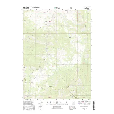
2017 Map of James Peak
USGS Topo · Published 2017About this map
James Peak and the high ridges of the Wasatch Range dominate this northern Utah landscape where Cache and Weber counties meet. The high-altitude terrain is defined by a series of steep drainages, including Mormon Hollow and Shingle Mill Hollow, which feed into major watercourses like the S Fork Little Bear River. The map provides clear evidence of the region's ranching and agricultural history through family-named landmarks such as Alex Beard Hill and McKenzie Mtn. Within the Cache National Forest, the topography transitions from the heights of Cobabe Peak down to McKenzie Flat. An interesting piece of water management infrastructure is visible at the northern edge where the Cache Valley Canal navigates the lower elevations. The network of forest roads and trails, including Flint Grove Rd and Public Grove ATV, reveals how this wilderness area is accessed for both resource management and recreation.
Find a feature on this map
50 named features on this map. Tap any name to fly to it.
Don’t see what you’re looking for? This feature index may not catch every label — zoom into the map to look around manually.
Map Details
Editions of this 2017 James Peak Map
This is the sole edition of this map. No revisions or reprints were ever made.
Other maps of this area

1914 · Logan
USGS Topo · 1:125,000

1916 · Logan
USGS Topo · 1:125,000

1954 · Ogden
USGS Topo · 1:250,000

1955 · Paradise
USGS Topo · 1:24,000

1955 · Mantua
USGS Topo · 1:24,000

1955 · Huntsville
USGS Topo · 1:24,000

1955 · James Peak
USGS Topo · 1:24,000

1955 · North Ogden
USGS Topo · 1:24,000

1955 · Mount Pisgah
USGS Topo · 1:24,000

1958 · Ogden
USGS Topo · 1:250,000
Featured Places
- Powder Mountain, UT
- Sundown Condominiums at Powder Mountain, UT
- Weber County, UT
- Cache County, UT
- Box Elder County, UT