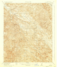
1921 Map of Jamesburg
USGS Topo · Published 1933About this map
The Santa Lucia Range dominates this 1921 survey, where the rugged terrain of Monterey County is defined by the canyon systems of the Carmel River and its numerous tributaries. Settled outposts such as Jamesburg and Rancho Del Monte anchor a landscape of high ridges, including Tularcitos Ridge and the Sierra de Salinas. The presence of Tassajara School, Tularcitos School, and Jamesburg School suggests a dispersed rural community reliant on these isolated valley bottoms for connectivity.
Find a feature on this map
65 named features on this map. Tap any name to fly to it.
Don’t see what you’re looking for? This feature index may not catch every label — zoom into the map to look around manually.
Map Details
Editions of this 1921 Jamesburg Map
5 editions found
Other maps of this area

1910 · Gonzales
USGS Topo · 1:31,680

1910 · Salinas
USGS Topo · 1:31,680

1910 · Soledad
USGS Topo · 1:31,680

1912 · Salinas
USGS Topo · 1:62,500

1913 · Monterey
USGS Topo · 1:62,500

1915 · Soledad
USGS Topo · 1:62,500

1918 · Point Sur
USGS Topo · 1:62,500

1919 · Junipero Serra
USGS Topo · 1:62,500

1920 · Jamesburg
USGS Topo · 1:48,000

1921 · Jamesburg
USGS Topo · 1:62,500