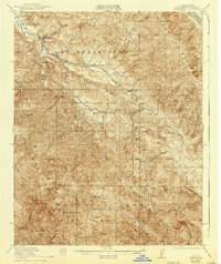
1921 Map of Jamesburg
USGS Topo · Published 1940About this map
The Carmel River and its numerous tributaries carve through the heart of the Santa Lucia Range in this early twentieth-century survey of Monterey County. Settlement is concentrated along the river valleys and ridges, marked by several rural education centers including Tularcitos School, Tassajara School, and Jamesburg School. Large landholdings and recreational sites define the local economy, from the Rancho Del Monte in the northwest to the Casa Verde Gun Club perched near Tularcitos Ridge. To the south, the landscape becomes increasingly high and remote within the Los Padres National Forest, where landmarks like Uncle Sam Mtn and the Ventana Double Cone overlook the Pine Valley. The map also preserves old Spanish land grant boundaries, such as the Guadalupe y Llanitos de los Correos, which persist alongside the developing infrastructure of the 1920s.
Find a feature on this map
65 named features on this map. Tap any name to fly to it.
Don’t see what you’re looking for? This feature index may not catch every label — zoom into the map to look around manually.
Map Details
Editions of this 1921 Jamesburg Map
5 editions found
Other maps of this area

1910 · Gonzales
USGS Topo · 1:31,680

1910 · Salinas
USGS Topo · 1:31,680

1910 · Soledad
USGS Topo · 1:31,680

1912 · Salinas
USGS Topo · 1:62,500

1913 · Monterey
USGS Topo · 1:62,500

1915 · Soledad
USGS Topo · 1:62,500

1918 · Point Sur
USGS Topo · 1:62,500

1919 · Junipero Serra
USGS Topo · 1:62,500

1920 · Jamesburg
USGS Topo · 1:48,000

1921 · Jamesburg
USGS Topo · 1:62,500