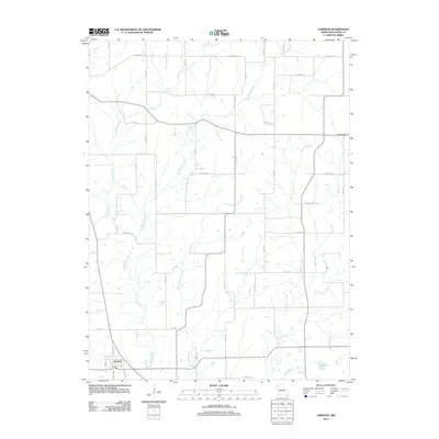
2012 Map of Jameson
USGS Topo · Published 2012About this map
The town of Jameson anchors the southwestern corner of this Daviess County landscape, where the local road network follows a strict sectional grid typical of the Missouri plains. This 2012 survey by the U.S. Geological Survey reveals a terrain deeply defined by its drainage systems, most notably the winding paths of Big Muddy Creek and Hickory Creek, which converge south of the primary settlement. The northern and eastern reaches of the map are largely agricultural, interspersed with family-named landmarks such as Hill Cemetery and small water bodies like Cook Lake. A complex network of local routes, including Beacon Ave and July Ave, connects the scattered farmsteads. The intricate detail of minor tributaries like Pilot Grove Creek and Little Muddy Creek provides a clear view of the natural hydrology that shaped local land use and property boundaries long after the initial pioneer settlement.
Find a feature on this map
26 named features on this map. Tap any name to fly to it.
Don’t see what you’re looking for? This feature index may not catch every label — zoom into the map to look around manually.
Map Details
Editions of this 2012 Jameson Map
This is the sole edition of this map. No revisions or reprints were ever made.
Other maps of this area

1922 · Gallatin
USGS Topo · 1:62,500

1924 · Winston
USGS Topo · 1:62,500

1925 · Pattonsburg
USGS Topo · 1:62,500

1925 · Gilman
USGS Topo · 1:62,500

1944 · Pattonsburg
USGS Topo · 1:62,500

1946 · Gilman
USGS Topo · 1:48,000

1946 · Pattonsburg
USGS Topo · 1:48,000

1948 · Gilman
USGS Topo · 1:62,500

1948 · Pattonsburg
USGS Topo · 1:62,500

1950 · Kansas City
USGS Topo · 1:250,000