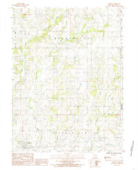
1984 Map of Jameson
USGS Topo · Published 1985About this map
The Grand River meanders through the southern edge of this Daviess County landscape, anchoring a complex drainage network that includes Big Muddy Creek, Mason Creek, and Pilot Grove Creek. The village of Jameson sits in the southwestern corner, serving as a primary point of settlement within a region largely defined by its rural townships, including Salem, Washington, and Lincoln. Small rural Cem sites are scattered throughout the quadrangle, providing important focal points for genealogical research into the area's farming families.
Find a feature on this map
14 named features on this map. Tap any name to fly to it.
Don’t see what you’re looking for? This feature index may not catch every label — zoom into the map to look around manually.
Map Details
Editions of this 1984 Jameson Map
This is the sole edition of this map. No revisions or reprints were ever made.
Other maps of this area

1922 · Gallatin
USGS Topo · 1:62,500

1924 · Winston
USGS Topo · 1:62,500

1925 · Pattonsburg
USGS Topo · 1:62,500

1925 · Gilman
USGS Topo · 1:62,500

1944 · Pattonsburg
USGS Topo · 1:62,500

1946 · Gilman
USGS Topo · 1:48,000

1946 · Pattonsburg
USGS Topo · 1:48,000

1948 · Gilman
USGS Topo · 1:62,500

1948 · Pattonsburg
USGS Topo · 1:62,500

1950 · Kansas City
USGS Topo · 1:250,000