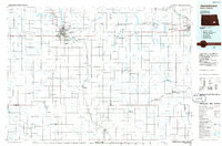
1986 Map of Jamestown
USGS Topo · Published 1986About this map
Jamestown and Valley City anchor this mid-1980s look at the agricultural heart of eastern North Dakota, where the James River and Sheyenne River valleys meet the prairie. The landscape is defined by the heavy presence of the Burlington Northern railroad and a sophisticated network of water management, evidenced by the Jamestown Reservoir and Pipestem Lake. Beyond the municipal centers, the survey details the systematic grid of rural townships like Corwin, Sydney, and Ypsilanti, each dotted with small grain-handling settlements and rural infrastructure.
Find a feature on this map
134 named features on this map. Tap any name to fly to it.
Don’t see what you’re looking for? This feature index may not catch every label — zoom into the map to look around manually.
Map Details
Editions of this 1986 Jamestown Map
2 editions found
Other maps of this area

1894 · La Moure
USGS Topo · 1:62,500

1895 · Lamoure
USGS Topo · 1:125,000

1896 · Jamestown
USGS Topo · 1:125,000

1896 · Edgeley
USGS Topo · 1:125,000

1897 · Tower
USGS Topo · 1:125,000

1897 · Eckelson
USGS Topo · 1:125,000

1900 · Pingree
USGS Topo · 1:125,000

1900 · Pingree
USGS Topo · 1:62,500

1918 · La Moure
USGS Topo · 1:125,000

1925 · Edgeley
USGS Topo · 1:125,000