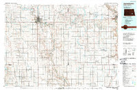
1986 Map of Jamestown
USGS Topo · Published 1989About this map
Jamestown and Valley City anchor this mid-1980s landscape where the James River and the Sheyenne River carve distinct valleys through the central North Dakota plains. The map illustrates a complex water management and conservation network, featuring the Jamestown Reservoir and Pipestem Lake, alongside numerous waterfowl production areas and wildlife refuges like Stoney Slough. This era shows the continued importance of the rail corridors, specifically the Burlington Northern and the Minneapolis St Paul and Sault Ste Marie RR lines that connect small prairie settlements such as Spiritwood, Ypsilanti, and Montpelier. Beyond the residential hubs, the presence of the State Hospital at Jamestown and the Valley City National Fish Hatchery highlights significant regional institutional footprints. The cartography reveals a highly organized township system, with many areas named for early settlers or geographic features, including Eldridge, Homer, and Sydney.
Find a feature on this map
130 named features on this map. Tap any name to fly to it.
Don’t see what you’re looking for? This feature index may not catch every label — zoom into the map to look around manually.
Map Details
Editions of this 1986 Jamestown Map
2 editions found
Other maps of this area

1894 · La Moure
USGS Topo · 1:62,500

1895 · Lamoure
USGS Topo · 1:125,000

1896 · Jamestown
USGS Topo · 1:125,000

1896 · Edgeley
USGS Topo · 1:125,000

1897 · Tower
USGS Topo · 1:125,000

1897 · Eckelson
USGS Topo · 1:125,000

1900 · Pingree
USGS Topo · 1:125,000

1900 · Pingree
USGS Topo · 1:62,500

1918 · La Moure
USGS Topo · 1:125,000

1925 · Edgeley
USGS Topo · 1:125,000