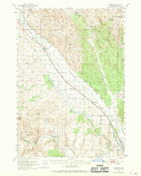
1950 Map of Jamieson
USGS Topo · Published 1970About this map
The Union Pacific railroad corridor defines the development of this Malheur County landscape, linking the small settlements of Jamieson, Dennis, and Lancaster (Willowcreek PO). The arrival of water through an intricate system of canals and siphons transformed this arid region, as evidenced by the Vale Main Canal, Gillerman Canal, and the substantial Hendrix Siphon. These irrigation works allowed for farming and ranching across Hope Flat and the surrounding drainages of Willow Creek and Bully Creek. Local industry and community life are represented by the Red Rock Quarry and the Bully Creek School located in the southern portion of the quadrangle. The terrain transitions from the low-lying flats toward prominent landmarks like Hope Butte and Sugarloaf Butte, while numerous springs such as McDowell Spr and McCarthy Spring provided essential water sources in the higher elevations near McCarthy Ridge.
Find a feature on this map
37 named features on this map. Tap any name to fly to it.
Don’t see what you’re looking for? This feature index may not catch every label — zoom into the map to look around manually.
Map Details
Editions of this 1950 Jamieson Map
3 editions found
Other maps of this area

1906 · Mitchell Butte
USGS Topo · 1:125,000

1950 · Jamieson
USGS Topo · 1:62,500

1951 · Moores Hollow
USGS Topo · 1:62,500

1951 · Huntington
USGS Topo · 1:62,500

1952 · Olds Ferry
USGS Topo · 1:24,000

1952 · Olds Ferry
USGS Topo · 1:62,500

1955 · Baker
USGS Topo · 1:250,000

1955 · Boise
USGS Topo · 1:250,000

1958 · Boise
USGS Topo · 1:250,000

1959 · Baker
USGS Topo · 1:250,000