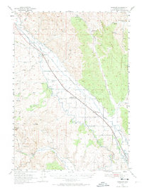
1950 Map of Jamieson
USGS Topo · Published 1974About this map
The Oregon Short Line and Union Pacific railroads define the development of this Malheur County corridor at mid-century, connecting small agricultural hubs across a landscape shaped by irrigation engineering. The settlement of Lancaster, serving as the Willowcreek Post Office, sits centrally alongside the tracks, while Jamieson and Dennis anchor the rail line to the north and south. The region's reliance on water management is evident in the network of canals, including the Vale Main Canal, Owyhee Canal, and Gellerman Canal, which divert water toward Hope Flat. Notable landmarks like the Hendrix Siphon and Morrison Reservoir highlight the technical infrastructure of the era. To the west, the Bully Creek School served the rural population near the base of Sugarloaf Butte, while the rugged eastern terrain is marked by McCarthy Ridge and numerous seasonal springs like McDowell Spr and Beirman Spring.
Find a feature on this map
41 named features on this map. Tap any name to fly to it.
Don’t see what you’re looking for? This feature index may not catch every label — zoom into the map to look around manually.
Map Details
Editions of this 1950 Jamieson Map
3 editions found
Other maps of this area

1906 · Mitchell Butte
USGS Topo · 1:125,000

1950 · Jamieson
USGS Topo · 1:62,500

1951 · Moores Hollow
USGS Topo · 1:62,500

1951 · Huntington
USGS Topo · 1:62,500

1952 · Olds Ferry
USGS Topo · 1:24,000

1952 · Olds Ferry
USGS Topo · 1:62,500

1955 · Baker
USGS Topo · 1:250,000

1955 · Boise
USGS Topo · 1:250,000

1958 · Boise
USGS Topo · 1:250,000

1959 · Baker
USGS Topo · 1:250,000