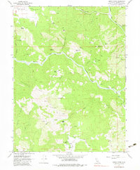
1967 Map of Jamison Ridge
USGS Topo · Published 1983About this map
Round Valley occupies the northwest corner of this Mendocino County survey, where the valley floor gives way to the complex elevations of Jamison Ridge and Pedro Ridge. The Middle Fork Eel River carves a deep path across the center of the sheet, joined by tributaries like Salmon Creek and Mill Creek. This landscape is defined by its working ranches and remote outposts, including Thrash Ranch, Marks Place, and the Eden Valley Ranch, the latter of which features its own Landing Strip. Local genealogy and history are preserved at the Pioneer Cem near the valley edge, while the presence of a Gaging Station on The Outlet reflects the importance of water monitoring in this river-driven terrain. Numerous springs, such as Redwine Spring and Iron Spring, are mapped along the many trails and canyons that traverse the slopes of Bald Mountain.
Find a feature on this map
46 named features on this map. Tap any name to fly to it.
Don’t see what you’re looking for? This feature index may not catch every label — zoom into the map to look around manually.
Map Details
Editions of this 1967 Jamison Ridge Map
3 editions found
Other maps of this area

1920 · Covelo
USGS Topo · 1:62,500

1926 · Covelo
USGS Topo · 1:62,500

1929 · Eden Valley
USGS Topo · 1:62,500

1951 · Laytonville
USGS Topo · 1:62,500

1952 · Spyrock
USGS Topo · 1:62,500

1952 · Eden Valley
USGS Topo · 1:62,500

1952 · Covelo
USGS Topo · 1:62,500

1957 · Ukiah
USGS Topo · 1:250,000

1960 · Ukiah
USGS Topo · 1:250,000
1966 · Sanhedrin Mtn
USGS Topo · 1:24,000