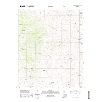
2020 Map of Jaralosa Mountain
USGS Topo · Published 2020About this map
Jaralosa Mtn and the surrounding high desert terrain define this corner of the New Mexico landscape, where the boundary between Socorro Co and Sierra Co crosses a network of deep canyons and peaks. This 2020 survey documents a region defined by its water sources, essential for survival in the arid environment, including Whitewater Spring, Witch Spring, and Rock Tank. The southern reach of the Cibola National Forest touches the northeast corner, while the Sierra Cuchillo range dominates the southern section. The map reveals the intricate drainage patterns of Alamosa Cr and numerous named draws such as Edwards Draw and Willow Spring Draw. These features, along with landmarks like Juan Peak and Bootlegger Gap, indicate a landscape primarily used for ranching and resource management, navigated by a sparse network of county roads including Co RD co33a.
Find a feature on this map
58 named features on this map. Tap any name to fly to it.
Don’t see what you’re looking for? This feature index may not catch every label — zoom into the map to look around manually.
Map Details
Editions of this 2020 Jaralosa Mountain Map
This is the sole edition of this map. No revisions or reprints were ever made.
Other maps of this area

1954 · Tularosa
USGS Topo · 1:250,000

1958 · Tularosa
USGS Topo · 1:250,000

1961 · Priest Tank
USGS Topo · 1:24,000

1961 · Monticello
USGS Topo · 1:24,000

1964 · Vicks Peak
USGS Topo · 1:24,000

1964 · Montoya Butte
USGS Topo · 1:24,000

1965 · Winston
USGS Topo · 1:24,000

1965 · Iron Mountain
USGS Topo · 1:24,000

1965 · Jaralosa Mountain
USGS Topo · 1:24,000
1965 · Chise
USGS Topo · 1:24,000