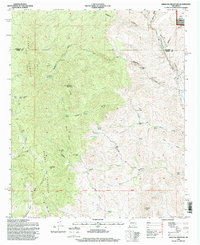
1995 Map of Jaralosa Mountain
USGS Topo · Published 1998About this map
The Sierra Cuchillo dominates this rugged portion of the Cibola National Forest, a landscape defined by deep drainages and volcanic peaks along the boundary of Socorro and Sierra Counties. In the mid-1990s, the terrain shows a sparse but persistent ranching and mining footprint, with family-named landmarks like Rouse Place and Chaves Place marking the survival of high-desert homesteads. The Alamosa River cuts through the northeast, while the Serna Mine sits perched above Whitewater Canyon, reflecting the area's mineral prospects.
Find a feature on this map
55 named features on this map. Tap any name to fly to it.
Don’t see what you’re looking for? This feature index may not catch every label — zoom into the map to look around manually.
Map Details
Editions of this 1995 Jaralosa Mountain Map
This is the sole edition of this map. No revisions or reprints were ever made.
Other maps of this area

1954 · Tularosa
USGS Topo · 1:250,000

1958 · Tularosa
USGS Topo · 1:250,000

1961 · Priest Tank
USGS Topo · 1:24,000

1961 · Monticello
USGS Topo · 1:24,000

1964 · Vicks Peak
USGS Topo · 1:24,000

1964 · Montoya Butte
USGS Topo · 1:24,000

1965 · Winston
USGS Topo · 1:24,000

1965 · Iron Mountain
USGS Topo · 1:24,000

1965 · Jaralosa Mountain
USGS Topo · 1:24,000
1965 · Chise
USGS Topo · 1:24,000