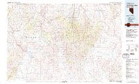
1981 Map of Jarbidge Mts
USGS Topo · Published 1991About this map
Humboldt National Forest dominates this northeastern Nevada landscape, where the high-altitude peaks of the Jarbidge Mountains and the Independence Mountains frame a history of mining and ranching. The presence of the Rio Tinto Mine and Golden Eagle Mine near Mountain City speaks to the region's mineral-driven development during the mid-20th century. To the east, the protected Jarbidge Wilderness preserves the drainages of the Jarbidge River and Marys River, showing a dramatic vertical relief that culminates at peaks like the Matterhorn. Small settlements such as Patsville, Rowland, and Charleston are scattered along the watercourses, while Nevada 225 provides the primary transit artery north toward the Idaho border. The impoundment of the Owyhee River at Wild Horse Reservoir creates a major focal point in the southwest, surrounded by landmarks like Wild Horse Mountain and Table Mountain.
Find a feature on this map
31 named features on this map. Tap any name to fly to it.
Don’t see what you’re looking for? This feature index may not catch every label — zoom into the map to look around manually.
Map Details
Editions of this 1981 Jarbidge Mts Map
3 editions found
Other maps of this area

1935 · Charleston
USGS Topo · 1:48,000

1936 · Mountain City
USGS Topo · 1:62,500

1936 · Rowland
USGS Topo · 1:48,000

1939 · Owyhee
USGS Topo · 1:62,500

1940 · Rowland
USGS Topo · 1:62,500

1940 · Mountain City
USGS Topo · 1:62,500

1942 · Owyhee
USGS Topo · 1:62,500

1942 · Mt. Velma
USGS Topo · 1:62,500

1943 · Jarbidge
USGS Topo · 1:62,500

1945 · Jarbidge
USGS Topo · 1:62,500