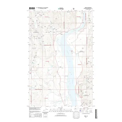
2014 Map of Jared
USGS Topo · Published 2014About this map
The Pend Oreille River anchors this 2014 survey of the Selkirk Mountains foothills, flowing northward through a valley defined by the Kanisku National Forest. Small settlements like Jared and Locke sit along the river's western bank, connected by the corridor of Wa-20. The landscape is a complex network of hydrological features, from the high mountain waters of Babbitz Lake near Babbitz Landing to the collection of smaller basins like Metcalf Lake, Lake Lucerne, and Brownie Lake. Numerous drainages including Cee Cee Ah Creek, Tacoma Creek, and Cusick Cr descend from the surrounding peaks toward the river valley. Prominent landmarks such as Gibraltar Rock and Sullivan Point provide clear orientation points for those studying the topography of this corner of Washington, where timber management and river geography have long dictated the pattern of local life.
Find a feature on this map
40 named features on this map. Tap any name to fly to it.
Don’t see what you’re looking for? This feature index may not catch every label — zoom into the map to look around manually.
Map Details
Editions of this 2014 Jared Map
This is the sole edition of this map. No revisions or reprints were ever made.
Other maps of this area

1934 · Metaline
USGS Topo · 1:125,000

1936 · Newport
USGS Topo · 1:96,000

1942 · Metaline
USGS Topo · 1:125,000

1942 · Newport
USGS Topo · 1:125,000

1958 · Sandpoint
USGS Topo · 1:250,000

1963 · Sandpoint
USGS Topo · 1:250,000

1967 · Timber Mtn.
USGS Topo · 1:24,000
1967 · North Baldy
USGS Topo · 1:24,000
1967 · Ruby
USGS Topo · 1:24,000

1968 · Cusick
USGS Topo · 1:24,000