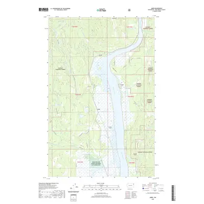
2020 Map of Jared
USGS Topo · Published 2020About this map
The Pend Oreille River dominates this portion of northeastern Washington, carving a wide path through the timberlands of the Kaniksu National Forest. Along its western banks, the small settlements of Jared and Locke serve as historic anchor points for a landscape defined by water and topography. Numerous small lakes and ponds, including Metcalf Lake, Lake Lucerne, and Babbitz Lake, are scattered throughout the basin, indicating a complex wetland ecosystem adjacent to the main river channel. High points like Ruby Mtn and Gibraltar Rock rise above the drainage systems of Cusick Creek and Tacoma Creek, which feed into the Pend Oreille. The presence of the Farm Service Agency Interest of Washington lands suggests a modern overlay of conservation or managed agricultural interests in this heavily forested river valley.
Find a feature on this map
48 named features on this map. Tap any name to fly to it.
Don’t see what you’re looking for? This feature index may not catch every label — zoom into the map to look around manually.
Map Details
Editions of this 2020 Jared Map
This is the sole edition of this map. No revisions or reprints were ever made.
Other maps of this area

1934 · Metaline
USGS Topo · 1:125,000

1936 · Newport
USGS Topo · 1:96,000

1942 · Metaline
USGS Topo · 1:125,000

1942 · Newport
USGS Topo · 1:125,000

1958 · Sandpoint
USGS Topo · 1:250,000

1963 · Sandpoint
USGS Topo · 1:250,000

1967 · Timber Mtn.
USGS Topo · 1:24,000
1967 · North Baldy
USGS Topo · 1:24,000
1967 · Ruby
USGS Topo · 1:24,000

1968 · Cusick
USGS Topo · 1:24,000