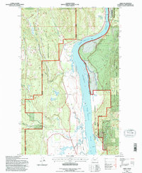
1992 Map of Jared
USGS Topo · Published 1996About this map
The Pend Oreille River corridor dominates this 1992 landscape, which traces the interface between the Kalispel Indian Reservation and the surrounding national forests. This area of Pend Oreille County shows the established settlements of Jared and Locke, alongside specialized land uses such as the USAF Survival School and the Little Pend Oreille State Wildlife Area. The geography is defined by numerous water bodies including Metcalf Lake, Babbitt Lake, and Browne Lake, which drain through systems like Cusick Creek and Tacoma Creek. Cultural and spiritual landmarks appear in the southern portion, specifically the Manresa Grotto and the Grange Hall. This Forest Service revision reflects a mid-1990s snapshot of a region balancing timber resources in the Kaniksu National Forest with preservation and indigenous land management.
Find a feature on this map
35 named features on this map. Tap any name to fly to it.
Don’t see what you’re looking for? This feature index may not catch every label — zoom into the map to look around manually.
Map Details
Editions of this 1992 Jared Map
This is the sole edition of this map. No revisions or reprints were ever made.
Other maps of this area

1934 · Metaline
USGS Topo · 1:125,000

1936 · Newport
USGS Topo · 1:96,000

1942 · Metaline
USGS Topo · 1:125,000

1942 · Newport
USGS Topo · 1:125,000

1958 · Sandpoint
USGS Topo · 1:250,000

1963 · Sandpoint
USGS Topo · 1:250,000

1967 · Timber Mtn.
USGS Topo · 1:24,000
1967 · North Baldy
USGS Topo · 1:24,000
1967 · Ruby
USGS Topo · 1:24,000

1968 · Cusick
USGS Topo · 1:24,000