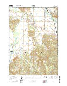
2014 Map of Jasper
USGS Topo · Published 2014About this map
The Middle Fork Willamette River and Coast Fork Willamette River converge in this valley landscape, framing the communities of Jasper and Creswell. This 2014 survey captures a pastoral and residential area defined by small agricultural hubs like Pleasant Hill and Cloverdale. The map is particularly useful for genealogists, as it identifies several established burial grounds, including the Pleasant Hill Cem, Mulholland Cem, Sellers Cem, and Cloverdale Cem, many of which are associated with the early settlement families of Lane County.
Find a feature on this map
57 named features on this map. Tap any name to fly to it.
Don’t see what you’re looking for? This feature index may not catch every label — zoom into the map to look around manually.
Map Details
Editions of this 2014 Jasper Map
This is the sole edition of this map. No revisions or reprints were ever made.
Other maps of this area

1910 · Eugene
USGS Topo · 1:62,500

1921 · Cottage Grove
USGS Topo · 1:62,500

1935 · Lowell
USGS Topo · 1:96,000

1940 · Eugene
USGS Topo · 1:62,500

1942 · Lowell
USGS Topo · 1:125,000

1946 · Eugene
USGS Topo · 1:62,500

1949 · Eugene
USGS Topo · 1:62,500

1950 · Marcola
USGS Topo · 1:62,500

1952 · Marcola
USGS Topo · 1:62,500

1953 · Salem
USGS Topo · 1:250,000